Trail Walking Le Mayet-de-Montagne - Boucle autour du Cluzel - Arronnes - Photo

Boucle autour du Cluzel - Arronnes

 tracegps
tracegps

User

© OpenStreetMap contributors
Length
Length
12 km
Max alt
Max alt
597 m
Uphill gradient
Uphill gradient
282 m
Km-Effort
Km-Effort  
15.8 km
Min alt
Min alt
465 m
Downhill gradient
Downhill gradient
281 m
Boucle
Boucle
Yes
Creation date :
2014-12-10 00:00:00.0
Updated on :
2014-12-10 00:00:00.0

(0 Reviews)

Walking
Walking
2h45
Difficulty : Medium

Scan this QR Code to open this trail in the SityTrail application

FREE GPS app for hiking

Logo SityTrail SityTrail

IGN / Geographical institutes

Download SityTrail from the App Store Download SityTrail from Google Play

Logo SityTrail SityTrail World

The world is yours!

Download SityTrail from the App Store Download SityTrail from Google Play Download SityTrail on Huawei AppGallery

About

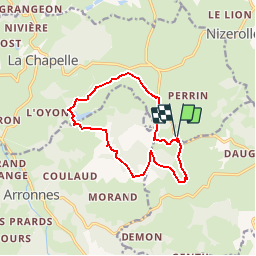
Trail Walking of 12 km to be discovered at Auvergne-Rhône-Alpes, Allier, Le Mayet-de-Montagne. This trail is proposed by tracegps.

Description

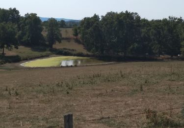
Départ parking bordant le RD.62 en bas du village du Cluzel. Partir en direction du Cros Pouthier, tourner à droite en direction du village Blanc et Chassenays. Se rendre sur Farillaud, étang de Mongaret, Chappes, les Vignauds. Prendre le RD.62 sur 300 mètres et prendre à droite dans une forêt de sapins et se rendre jusqu'au village du Cluzel puis redescendre jusqu'au parking (12km - Chemins larges - rando facile -cumul des montées 352 mètres).

Elevation profile

Photos

Positioning

Country:
France
Region :
Auvergne-Rhône-Alpes
Department/Province :
Allier
Municipality :
Le Mayet-de-Montagne
Location:
Unknown
Start:(Dec)
Start:(UTM)
547801 ; 5102404 (31T) N.

Trails nearby

Trail Other activity Arronnes - GC Mayet Ferrière - Photo
Other activity
hub03

Other activity

Very easy
(1)
Arronnes, Auvergne-Rhône-Alpes, Allier, France
27 km | 34 km-effort
5min
No
Trail Running Châtel-Montagne - jour 7 CAP Jeanot - Photo
Running
jeannat

Running

Very easy
Châtel-Montagne, Auvergne-Rhône-Alpes, Allier, France
33 km | 43 km-effort
4h 29min
No
Trail Walking Châtel-Montagne - Le Puy du Roc - Châtel-Montagne - Photo
Walking
tracegps

Walking

Medium
Châtel-Montagne, Auvergne-Rhône-Alpes, Allier, France
10.2 km | 15.3 km-effort
3h 0min
Yes
Trail Hybrid bike Châtel-Montagne - jour 7 - Photo
Hybrid bike
nathbab

Hybrid bike

Very easy
Châtel-Montagne, Auvergne-Rhône-Alpes, Allier, France
27 km | 32 km-effort
2h 6min
No
Trail Walking Châtel-Montagne - Balade autour du Mont Aigu - Le Moulin Chatel - Photo
Walking
tracegps

Walking

Medium
Châtel-Montagne, Auvergne-Rhône-Alpes, Allier, France
10.4 km | 14.1 km-effort
2h 30min
Yes
Trail Walking Le Mayet-de-Montagne - Le Grand Roc - Le Mallot - Photo
Walking
tracegps

Walking

Medium
Le Mayet-de-Montagne, Auvergne-Rhône-Alpes, Allier, France
10.4 km | 15.2 km-effort
2h 45min
Yes
Trail Quad Ferrières-sur-Sichon - rando - Photo
Quad
cdecloitre

Quad

Very easy
Ferrières-sur-Sichon, Auvergne-Rhône-Alpes, Allier, France
72 km | 103 km-effort
5h 17min
Yes
Trail Walking Châtel-Montagne - Chatel Montagne - centrale hydroelectrique - Photo
Walking
coco03

Walking

Easy
Châtel-Montagne, Auvergne-Rhône-Alpes, Allier, France
11.9 km | 17.1 km-effort
3h 40min
Yes
Trail Walking Arronnes - Balade sur Arronnes - Photo
Walking
jdcc

Walking

Medium
Arronnes, Auvergne-Rhône-Alpes, Allier, France
16.3 km | 23 km-effort
4h 52min
Yes


Close
My subscriptions